
Measure. Map. Understand.
Our autonomous oceanographic USV is custom-designed for bathymetry, hydrography and water quality monitoring missions.
Thanks to a modular architecture, it can incorporate various sensors: sounder, multibeam sonar, GNSS RTK, CTD, turbidity, pH, dissolved oxygen, chlorophyll, ADCP, etc.
Whether autonomous or remotely operated, the USV performs precise and repeatable measurement campaigns, while transmitting data in real time.


One platform. One mission. One custom configuration.
Bathymetry
Precise mapping of the seabed and detection of depth variations.
Water quality
measurement of physico-chemical parameters and detection of anomalies.
Hydrography
survey campaigns in coastal, port, river or lake areas.
Environmental monitoring
monitoring the evolution of an environment and identifying changes.
Sediment monitoring
observation of areas of accumulation, erosion or resuspension.
Inspection of submerged infrastructure
data collection around quays, dikes, structures and maritime installations.

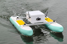

From USV to the complete oceanographic solution
USV → Autonomous Navigation → Scientific Sensors → Data Acquisition → Transmission → Processing → Mapping → Analysis
The objective is to provide teams with an autonomous, mobile and configurable measurement platform, capable of transforming a maritime area into a true data acquisition field.


